Llyn Melynllyn and Llyn Dulyn Circular (5.67miles / 9.12km)
As I was researching the history of our recent walk to Cwm Eigiau I came across the name Llyn Dulyn, a small reservoir up in the hills above the broken dam of Llyn Eigiau. I went off on a research tangent and the more I read, the more I wanted to visit this remote lake. My main concern though was whether getting to Llyn Dulyn was beyond my fitness and abilities. I am possibly over anxious when it comes to walking in the mountains. Having lived in their shadow most of my life I am hyper aware of how quickly things can go wrong and I desperately don’t want to be that person airlifted off the mountains because I’ve made a stupid mistake... especially not with a baby in tow!
So I research and studied, and studied and researched until I came to the conclusion that if I was super careful, and willing to turn back if necessary, this walk could be managed. I took advantage of the fact that Megan was away and set off with Anwen. I’m glad Megan wasn’t with us as I think sections of the walk would have been a bit much even for her, but on the whole, this was a very manageable walk. There’s one steep downhill section and a few boggy areas, so sensible walking boots are a must and my stick came in very handy too. The path is a little tricky to follow in places down the valley so I was glad I had my OS Map app on my phone, although being in a valley means there are only so many places you can wander to! I didn’t want to end up in a bog though!
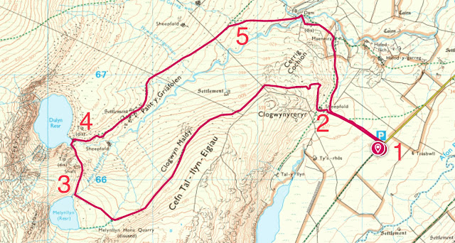
Distance: 9.12km / 5.67 miles (according to the OS map app)
Time taken: 2hrs 28mins.
Total ascent: 1083.27ft / 330.18m (OS map app)
Parking: Yes, free parking up a long narrow track near Eigiau Dam.
Facilities: None.
Walkers: myself (33 yrs, fat and unfit) and Anwen (15 months, in the rucksack).
1. We parked in the same place as when we visited Cwm Eigiau, so I’ll share the same instructions as I wrote for that walk.
“To park you need to turn up the hill off the B5106 in the village of Tal Y Bont near Dolgarrog (Doll garr ogg) in the Conwy valley. There is, of course, no signpost so I recommend studying a map as it’s an extremely uninviting road and only gets worse the further you go. I had researched thoroughly and even I had my doubts as I wound my way up the narrow, steep lane. Not long after passing a junction on your left you arrive at a gate across the road. It’s at this point you really begin to question yourself, and in fact the car behind me reversed back down, clearly thinking they had come the wrong way. I had the OS map app open and could see that this was the correct road to reach the parking. After going through the first gate (Make sure to leave all gates as you find them) you pass a farm on your right, then quickly reach another gate to go through. You continue along the road until you eventually reach a third and final gate to pass through. The dam soon comes into view, looming in the distancing, and confirming that you are, in fact, on the right road! It’s not long after this that you arrive at the parking area, which has plenty of room for numerous cars and space to turn around.”

Map showing the road from Tal Y Bont to the parking area.
Once we parked up, we turned to face back up the road we had just travelled down (away from the dam) and hopped over a stile onto a track leading up the hill on our left.
Hop over the stile.
Follow the track up the hill.
From what I could gather in my research before the walk, this was an old quarryman’s track - the Melynllyn Quarry Road. We will follow this track for the first half of the walk as it takes us all the way to the first lake, Llyn Melynllyn (Tl inn Mel in tlinn- Lake Yellowlake is the literal translation), where the quarry was located. Although it’s uphill nearly all the way, it’s pretty easy walking as the track is easy to follow and you don’t have to worry about getting lost or wandering into any dangerous areas!
2. At the top of this first section we pass through a gate then pass another track which joins us on the right just before going in between two massive rocks on either side. The path to the right is our return path.
Return path leads off to the right just out of shot, before the rocks.
After passing between the rocks we come across an old sheepfold. There are a lot of scattered remains of buildings and enclosures in this area. The track loops up and around Clogwynyreryr (Clog win urgh err irr- Cliff of the eagle) first to the right and then to the left to pass between Clogwynyreryr on the left and Cerrig Cochion (Kerr igg Koch yon - Red stones) on the right.
Passing the sheepfold on the right.
Looking down on the sheepfold with the track we’ve just climbed beyond.
Looking back at the sheepfold.
Onwards and upwards.
Look out for some standing stones along this section. There are four listed on Coflein but I only noticed a couple, the tallest being quite impressive at over a metre tall.
Standing stone.
Looking back the way we’ve come (you can see the standing stone by the track).
Winding among the heather.
Happy faces!
Heading along the valley.
Looking back the way we’ve come.
Our first glimpse of Llyn Dulyn across the valley.
Heading for Llyn Melynllyn (at the bottom of the cliffs at the far end of the valley)
After dropping down towards Llyn Melynllyn, which is hidden from view until we get to the end of the quarryman’s track, the track veers to the right past the remains of an old quarry building belonging to the Melynllyn Hone Quarry. We can see the remains of the quarry itself on the slope above the building.
Melynllyn Hone Quarry.
Although water from Melynllyn reservoir is now piped to Dulyn reservoir as part of the Dolgarrog hydroelectric scheme, the dam was originally built about 1887 to supply water for power to the Melynllyn Hone Quarry. First started as a slate prospect, some of the slates was found to have the quality required for honing stones and the quarry operated following the vein until 1907. Melynllyn became a well-known trademark for very fine honing stones.
Little survives of the original cutting and splitting mechanism of the hone-stone mill at Melynllyn except the iron shaft from the water wheel.
During the Second World War in 1943 an Anson EG110 aircraft crashed above Cwm Dulyn. Pilot officer Ken Archer somehow in total darkness and seriously injured made his way down the rocks at the side of Llyn Dulyn to get help. It took him 17 hours to get down the mountain. A search party of 35 men then searched all night. Eventually the wreck was reached but it was too late for two of the crew, with only one surviving the cold and, by then, snow. The hone stone quarry buildings were used by the search parties seeking the lost plane.
Melynllyn Quarry Building (Honestone mill) with the quarry itself on the slope above. The rusting machinery is a hand- operated winch or crab. On the right inside the building are hone-stones left when the quarry closed.
In the gap you can see a take-up pulley wheel which conveyed power to machinery via a moving belt. There would once have been a water wheel connected.
We cross the bridge over the leat alongside the mill building and make the most of this final section of track!
Bridge over the leat.
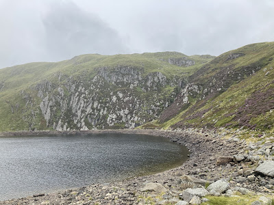
3. The quarryman’s path runs out when we get to the corner of Llyn Melynllyn. The weather hadn't been great since we started the walk but it began to turn pretty bleak at this point which really wasn’t what I wanted given that we had now reached the end of the easy section! Luckily, as is common with weather in the mountains, it improved as quickly as it worsened so we pushed on.
Llyn Melynllyn.
Llyn Melynllyn
The lake lies at a height of just over 2000 feet, and has an area of some 18.5 acres. Cliffs rise steeply from its western edge, up to the summit of Foel Grach, and down from which most of its feeder streams flow. A small dam was built at its northern end in 1887, but this was deliberately breached in 1970. The lake acts as a reservoir for the Llandudno area. The outflow from the lake is called Afon Melynllyn, the stream flowing north-east to join Afon Dulyn, itself a tributary of the river Conwy.
Bridge over a dry river.
Relief to get to flatter ground.
Although the quarryman’s track has vanished at this stage, the path ahead is fairly obvious, if narrow and uneven. After crossing the dry river we follow the path right then curve around the hill to the left.
Path over the rise towards Llyn Dulyn.
Impressive views down the valley.
Starting to get steeper.
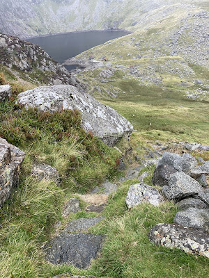
To begin with it appears as if you have it easy by going around the base of the steep section. However, as soon as you start to curve around the hill to the left the track begins to sharply drop down towards Llyn Dulyn. This really is the steepest section of the walk and although I was glad Megan wasn’t with me as an added concern, I didn’t find it too scary at all. I took my time, used my stick for balance and picked my way steadily down. I didn’t have to get on my bottom once (something which I am never too proud to do, and have often had to do on the coast path on Anglesey). There were even some steps at one point. Steep, slippery ones, but steps nonetheless. I’m sure Anwen was bounced about a bit, but if she minded she never mentioned it!
When we were nearly at the bottom (and I was feeling pretty chuffed with myself) we met a man coming the other way (the only person I saw on the whole walk). He had walked that morning from above Aber Falls! Despite making me feel very inadequate, he was lovely. We had a chat about carrying one year olds about and he warned me that the path ahead was tricky to follow and a bit boggy. I thanked him and headed off again. By the time I looked back, he had vanished up the section I had just struggled down!
Steps! Still a long way to go down though!
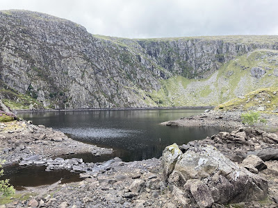
4. And so we arrived at the goal, Llyn Dulyn. I suppose I’d better share some of the information that I read which made me so keen to visit this out of the way little lake.
Llyn Dulyn.
Llyn Dulyn is a small cirque lake bound by the high cliff faces of Garnedd Uchaf and Foel Grach on the edge of the Carneddau mountains. It is approximately 33 acres in area, has a mean depth of 104 feet, and is 189 feet at its deepest point. The lake has a dam which was constructed in 1881, and it now serves as a reservoir for Llandudno. It is one of the lakes where the Arctic Char can be found in Wales.
It is said that there was once a causeway out into the lake (this would now be submerged due to the raised water level). At the end of the causeway was a red coloured rock known as Yr Allor Goch or “The Red Altar”. It was said that anybody who wet this rock would cause it to rain.
An account translated from a Welsh magazine printed in 1805:
“There is a lake in the mountains of Snowdon, called Dulyn, in a rugged valley, encircled by high steep rocks. This lake is extremely black, and its fish are deformed and unsightly, having large heads and small bodies. No wild swans are ever seen alighting upon it (such as are on all the other lakes in Snowdon), nor ducks, nor any bird whatever. And there is a causeway of stones leading into this lake; and if anyone goes along this causeway, even when it is hot sunshine, and throws water so as to wet the furthest stone, which is called The Red Altar, it is a chance if it does not rain before night. Witness, T. Prys, of Plas Iolyn, and Siôn Davydd, of Rhiwlas, in LlanSilin.”
Llyn Dulyn and the Allor Goch may relate to the fountain, as depicted in the Mabinogion’s Iarlles Y Ffynnon “The Lady of the Well”.
“And Owain followed the road, as Kynon had done, till he came to the green tree; and he beheld the fountain, and the slab beside the fountain, with the bowl upon it. And Owain took the bowl, and threw a bowlful of water upon the slab. And, lo, the thunder was heard, and after the thunder came the shower, much more violent than Kynon had described, and after the shower the sky became bright.”
Other beliefs surround this lake. One shared by the shepherds of the region says that when a dove appeared near the lake, it meant that a beautiful but wicked woman had descended to hell. Another legend connected with this place says that anyone who dares to watch beside the lake on certain festival nights I.e. Midsummer, May Day or All Hallow’s Eve, would see those who were to die within the next 12 months. Of those, the ones that had led bad lives would be taken by demons into the black waters, while good people would be led to the lake where they would vanish into spirit forms dressed in white. It was believed that a famous witch from the region had been dragged into the waters of the lake.
In June 1284 the lake was the setting for the court of Kind Edward I of England for victory celebrations, following his defeat of Llywelyn ap Gruffudd and the conquest of Wales. The celebrations included the king’s 45th birthday and had an Arthurian theme.
The cwm has been the site of a number of aeroplane crashes, including that of an American Dakota aircraft which crashed into the cliffs above the lake in 1944, killing all four crew. At least eight aircraft plummeted into the lake during WWII.
So, a little lake with a lot of history and legends surrounding it. I took a little time looking out at the lake and enjoying the peace and quiet. As you can see from the pictures the water levels were quite low, following some hot weather here in North Wales. I had read that the propellor from the crashed Dakota
plane, which was normally underwater, could be seen when the water level was low. It was still quite a chilling sight to see when I turned to my right and saw its twisted remains lying not so far from where I was stood. It was very sobering to see and to think about the fate of the young men who died in and around this lake. You can still read the writing on one of the blades which tells us its part number.
Propellor of the Dakota aircraft which crashed into the cliffs beyond.
Llyn Dulyn and propellor.
Llyn Dulyn.
Dakota crash
The crew were flying the aircraft from Le Borget airport near Paris to Burtonwood in Cheshire. They had departed at 08:30 (local) on the 11th November 1944 with a flight of three other C-47s which were also bound for Burtonwood. On nearing the airfield they were informed that it was closed due to bad weather and that they should divert to RAF Valley where weather conditions were suitable. They acknowledged this order and proceeded towards North Wales at just before 13:00 GMT. No further radio communication was had with the crew and after failing to arrive at RAF Valley the aircraft was declared as overdue.
By the time it had been declared overdue it was too late to conduct an air search for the missing C-47 so the following morning an aircraft (probably an Anson) from no.9 (O) AFU at Llandwrog with the Senior Medical Officer (and leader of the Mountain Rescue Team) onboard left to conduct a search of the mountains of Snowdonia. Attention was paid to the Carneddau range where it was thought the aircraft may have crashed, as experience had shown aircraft approaching from the east usually came to grief on this range. No wreckage was spotted and the search by the RAF was stood down. Strangely no ground search was ordered.
On the 22nd of November the wreck was located by an RAF radio unit which was carrying out maintenance on a warning beacon which had been placed on the summit of Foel Grach. The wreckage of the aircraft was spotted high up on the cliffs of Craig Y Dulyn above the Dulyn reservoir.
During the autumn of 1972 parts of the aircraft were recovered from the lake by the Warplane Wreck Investigation Group and the West Bromwich Underwater Exploration Club. One of the items recovered was the tailfin of the aircraft. It went on display at the WWIG’s museum, which is currently located at Fort Perch Rock in New Brighton. One of the two propeller units from the aircraft was recovered from the bed of the reservoir and brought to the spillway by divers.
| William C. Gough | 2nd Lieutenant | Pilot | Killed |
| Richard R. Rolfe | 2nd Lieutenant | Co-pilot | Killed |
| Hyman Levitski | Corporal | Radio Operator | Killed |
| Kirk McLoren | Staff Sergeant | Flight Engineer | Killed |
Crew of the crashed Dakota.
Two of the crew were buried at Cambridge American Cemetery.
The Dakota is only one of many, many aeroplane tragedies in the area. In fact, the area is littered with scars and remains of numerous aircraft crashes. There is a list here of some of the sites - https://www.peakdistrictaircrashes.co.uk/tag/carneddau/
After a quick snack for me and Anwen we set off for home. I considered for a second going back the way we had come, but was put off by the thought of climbing back up the slope we had come down. By this point the weather had improved a lot and I figured that it would be pretty hard to get lost in a long, narrow valley with only one direction to head in! We made our way first of all towards the Dulyn Bothy, which is an easy and nearby landmark to head for. My research and the advice from our friendly hiker was right. The path was pretty easy to follow on the whole, but every now and then it just vanished amongst rocks or marshy sections. I kept my OS app to hand and was easily able to get myself back on track each time.
After the bothy I aimed for the clump of trees that stand out as the only trees in the valley! I wonder if, like at Cwmorthin, they were something to do with the quarry and there would once have been a building there. It seems odd that older buildings remain but that one had vanished completely though. Who knows?
First step, aim for the bothy.
Spot the path.
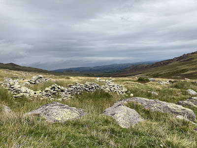
Remains of the Pant y Griafolen Bronze Age settlement.
Looking down the valley with Afon Dulyn winding its way on our right.
Despite my previous concerns, the walk back down the valley was reasonably straightforward. I did get muddy feet, but we weren’t sucked down into any bogs never to be seen again... and I didn’t get lost! The only think that nearly foiled me was a stile! I saw it coming in the distance and my heart sank. Climbing over solid, chunky stiles is hard with a baby on your back, but this one was a rickety, slippy metal atrocity. Luckily, someone had cut the top wire of the fence and I was able to step over pretty easily (I say luckily with some reluctance. As a farmer’s daughter, I am disgusted with that human being for cutting a fence. However, as a walker with a baby, I think they’re wonderful human beings and I thank them forever!)
What an abomination.
Another sheepfold.
Whoever came up with these things... I hate you.
More beautiful views though!
We made it though, and on we went. During this section from the lake, the map had shown that we had needed to cross a few streams. So far they had all been a little hop over and nothing to worry about. The final stream, before veering right and heading down towards the little dam, looked as if it had a bridge on the satellite picture. Now it might very well have a bridge, but I had somehow managed to come off the path and crossed lower down, where there was certainly no bridge! So, if you’re following this make sure you keep left to go over the Afon Garreg Wen. Don’t bitch and moan like I did that the path had gone down a bit steep, that the stones were slippy, that my feet were wet and that the climb on the other side was steeper than expected too... because if you’re moaning about these things, chances are you’ve made the same mistake as me. I mean really it wasn’t that bad, and I did get to see a pretty little waterfall. Every cloud and all that. I’d love to know if there actually is a bridge though!
Afon Garreg Wen. Is there a bridge over there? Who knows... certainly not me.
Afon Ddu coming down from the left to join Afon Dulyn.
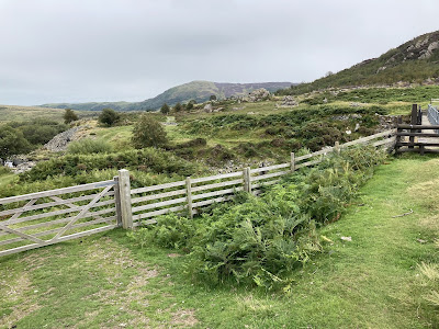
I had worried (shocking right!?) that there would be no way to cross the rivers at the dam, and that I would be forced to do an epic return trip (like when we visited Eigiau, but worse!). However, I needn’t have worried as there were actually two ways of crossing. To the left, a gate onto a track with a ford. To the right, a stile to cross the dam. We went right, across the dam.
Ford or dam?
Looking back up the valley for the last time.
You can see the ford just beyond the Rowan tree.
After crossing the dam we joined back onto the track and basically followed it home! It climbs a little and joins back onto the original quarryman’s track just below the first sheepfold and we turn left, back through the gate and down the hill to the car park.
Lots of Rowan trees- my favourite kind of tree.
Rowan tree.
Nice wide track back.
Ruins of an old farmhouse called Maeneira, with Moel Eilio in the background.
Clogwynyreryr rising up in front of us.
Joining back onto the original track. Nearly home!
Someone’s tired!
Sources












Comments
Post a Comment